We’ve all been there: staring at a trailhead, wondering if that path is a gentle stroll or a thigh-burning nightmare. Topographic maps are your cheat code to the wild, turning a mess of hills and valleys into a plan you can actually follow. Those weird lines and cryptic numbers reveal the land’s secrets, but to a beginner, they can look like a toddler’s scribbles.
Whether you’re hiking a mountain trail or driving a dusty backroad, mastering these maps means smarter, safer adventures. This guide breaks down elevation contours, gradients, and practical tips for planning trips—plus a hands-on “how to practice” activity to get you started. Let’s untangle the lines and take control of the terrain.
What’s a Topographic Map, Anyway?
Topographic maps (or “topo maps”) go beyond basic GPS apps. They show the earth’s shape with lines, symbols, and colors that detail elevation, terrain, and distances. Think of them as a 3D landscape squashed flat. For hikers and backroad drivers, they’re essential—highlighting steep climbs, gentle slopes, or cliffs you’d rather not meet.

Unlike Google Maps, topo maps reveal how tough a route will be. They’ll warn you about a 1,000-foot ascent or a swampy detour that could stall your vehicle. Ready to decode them? It all starts with the map’s MVP: contour lines.
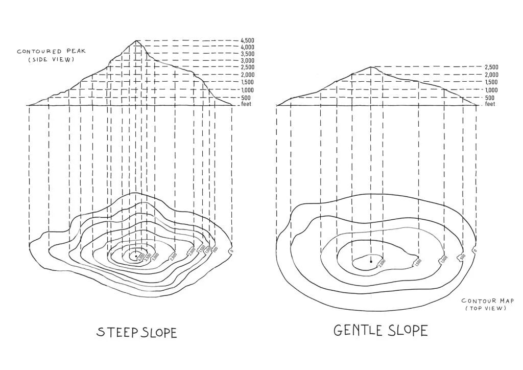
Contour Lines
Contour lines are the squiggly loops that show elevation. Each line connects points at the same height above sea level, like a snapshot of the terrain at that altitude. Here’s the breakdown:
- Spacing: Tight lines mean a steep slope—think a cliff or a lung-busting climb. Wide lines signal gentle terrain, like a meadow or easy hill.
- Numbers: Index contours (every few lines) show elevation (e.g., 5,000 ft), helping you track your height.
- Shape: Concentric circles mark hilltops or depressions (like craters). V-shaped contours point uphill to ridges or downhill to streams.
Check the contour interval—the vertical height between lines (e.g., 40 ft), found in the map’s legend. A smaller interval gives more detail but can make slopes look deceptively mild. Misjudge this, and you’re in for a surprise.
How Steep Is Too Steep?
Gradient measures terrain steepness, and topo maps make it easy to calculate. For hikers, a 10% grade (10 ft rise per 100 ft forward) is manageable; 20% will leave you gasping. For drivers, grades over 8% can strain a vehicle, especially on loose gravel.
To estimate gradient:
- Count contour lines crossed over a distance (use the map’s scale, e.g., 1 inch = 1 mile).
- Multiply by the contour interval to get elevation change.
- Divide elevation change by horizontal distance and convert to a percentage.
Example: A trail crosses 5 contour lines (40 ft interval) over 0.25 miles (1,320 ft). Elevation change = 5 × 40 = 200 ft. Gradient = (200 / 1,320) × 100 ≈ 15%. That’s a solid hike or a careful drive.
Tip: Apps like Gaia GPS or CalTopo generate elevation profiles for your route, showing gradient shifts instantly. Still, keep a paper map handy—batteries die, but paper doesn’t.
Key Features to Spot
Topo maps are loaded with symbols that scream “watch out.” Here’s what beginners need to know:
- Blue Lines: Rivers, streams, or lakes. Wiggly lines often mean seasonal streams—check recent weather to avoid wading.
- Green Areas: Forests or thick vegetation. Good for shade, tricky for off-trail treks.
- Brown/Red Lines: Trails, roads, or jeep tracks. Dashed lines might mean unmaintained paths—tread lightly.
- Black Dots/Names: Landmarks like peaks, cabins, or mines. Use these to stay oriented.
Always check the map’s legend to confirm what symbols mean. A “spring” might be dry, or a “trail” might be a faint path. Cross-reference with recent trip reports for accuracy.
Planning Smarter Trips with Topo Maps
Topo maps are your best friend for route planning. Here’s how to use them effectively:
Choose Wisely: Pick paths with widely spaced contours for easier hikes or drives. Avoid tight contours unless you’re up for a grind.
Time It Right: Factor in elevation gain. Hikers: Add 1 hour per 1,000 ft of gain to your flat-terrain pace. Drivers: Expect 20-30 mph on steep, rough roads.

Find Exits: Identify nearby trails or roads for emergencies. A topo map can show a quick escape to a highway if weather turns or your car falters.
Locate Resources: Look for springs, lakes, or flat areas (wide contours) for campsites. Verify water sources online, as some dry up seasonally.
A well-planned route can save hours and energy. Use the map’s scale to measure distances accurately, and always note key landmarks for navigation.
Tech vs. Paper: The Best of Both Worlds
Paper topo maps are reliable but bulky. Digital tools like Gaia GPS, AllTrails Pro, or CalTopo offer zoomable topo layers and GPS tracking. Download maps offline—cell towers don’t exist in the backcountry. For paper, USGS maps (available at usgs.gov) are top-notch in the U.S., but you’ll need prints or PDFs.
Try a hybrid: Scout routes digitally, then print a small map section for your trip. Paper maps are lifesavers when tech fails, so keep one in your pack.
Common Mistakes to Avoid
Newbies often stumble here:
- Wrong Scale: A 1:24,000 map (1 inch ≈ 2,000 ft) is detailed but covers less ground. A 1:100,000 map shows more but skips fine details. Pick the right scale.
- Misreading Contours: Tight lines aren’t always gentle—check the interval. A 10-ft interval is steeper than a 50-ft one.
- Ignoring the Legend: Symbols differ by publisher (USGS vs. National Geographic). Read the legend to avoid confusion.
- App Overload: GPS apps can lag or crash. Practice with paper maps to stay sharp.
Avoid these traps, and you’ll navigate with confidence.
Why It Matters
Topo maps aren’t just for hardcore trekkers—they’re for anyone who wants to explore smarter. In Wyoming’s Wind River Range, a topo map helped me skirt a snowfield that looked “fine” from afar but was a 30° slope. Those lines revealed the danger, saving me from a risky crossing.
Reading topographic maps is like learning to read the land itself. It takes a bit of practice, but soon you’ll see hills as challenges, valleys as rest stops, and every contour as a clue.